Using Artificial Intelligence to Automate Utilities Asset Inspection & Inventory

Using Artificial Intelligence to Automate Utilities Asset Inspection & Inventory

Home 9 Project Category: App Development ( Page 2 )

Case studies

Using Artificial Intelligence to Automate Utilities Asset Inspection & Inventory

Client

Industry

Energy & Utilities
Survey & Inspection
Consumer Applications

Region

Worldwide

Technology

Artificial Intelligence

Overview

GISonLine, in partnership with the Wrocław University of Technology, are working closely on a project designed to use Artificial Intelligence (AI) and machine learning to process and analyze high resolution imagery to automate utility inspection and asset management workflows.

Integrating AI into the inspection & asset management processes has the potential for significant costs savings and benefits. By using AI and machine learning techniques, utility asset managers and inspectors have the ability to automate the process of identifying and inventorying utility objects and to use the AI algorithms to flag assets recognized as having visible defects or faults.

The Impact

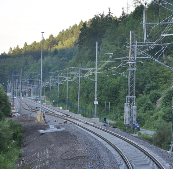
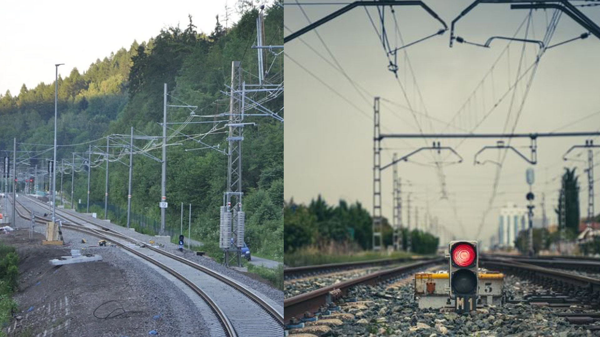
GISonLine is specifically focusing on creating AI algorithms and image pattern recognition for the processing of digital images of railway traction lines obtained from drone and UAV platforms. Traction lines and their connected utility objects are used in support of overhead contact lines associated with electrical power distribution for railway networks.

The formalized process will utilize machine learning techniques to detect and identify the railway traction lines and connected network objects. A primary goal is to train the system for pattern recognition to detect and flag visible defects (faults) found along the traction lines and to automatically alert personnel and inspectors of the issues and maintenance needed.

The Outcome

GISonLine’s objective is to integrate the AI and machine learning technology into its INSPECTonLine cloud-based application.

The INSPECTonLine product will enable asset managers and inspectors with the ability to automate the processes associated with utility asset inventories & inspections and provide a formalized method for detecting and alerting personnel of utility defects that require closer inspection.

Phases of the project include:

1. Analysis of source data and materials (drone & aerial platform data)
2. Definition & characteristics of utility objects to be analyzed
3. Development of traction line recognition algorithms
4. Pattern recognition and feature/fault identification
5. Analysis of the solution for maintaining railway overhead contact lines
6. Integration of the algorithms into the INSPECTonline application


See some things

we’ve worked on

Contact us

Looking for Location Intelligence?

7 + 10 =

Integrating Esri ArcGIS Capabilities in Support of District Heating Asset Management (Krakow, Poland)

Integrating Esri ArcGIS Capabilities in Support of District Heating Asset Management (Krakow, Poland)

Home 9 Project Category: App Development ( Page 2 )

Case studies

Integrating Esri ArcGIS Capabilities in Support of District Heating Asset Management (Krakow, Poland)

Client

Industry

Energy & Utilities
Local Government

Region

Europe

Technology

ArcGIS Web AppBuilder
JavaScript, HTML, CSS
Esri ArcGIS Enterprise
Portal for ArcGIS
PostgreSQL
FME
SmallWorld
.Net Core

Client: MPEC
Location: Krakow, Poland

In support of MPEC (Miejskie Przedsiębiorstwo Energetyki Cieplnej) business operations and the supply of district heating to Krakow residents, GISonLine provided geospatial mobile applications and custom web portals that provided geospatial resources and capabilities to MPEC’s asset management processes.

MPEC is one of the leaders in the heating industry in Poland providing heat to over 65 percent of residents in the city of Krakow. Heat from the MPEC utility network (almost 900 kilometers long) supports the heating of municipal entities such as: housing estates, shopping malls, congress halls, offices, schools, hospitals and churches.

The Impact

MPEC’s activities and infrastructure are important for the environment and addressing the city of Krakow’s air quality due to smog.  Notably, the transition of gas stoves being replaced with MPEC’s central hot water system.  Having a geospatial system designed for managing MPEC’s existing utility infrastructure and to serve as a tool for planning future development are key aspects of modernization and successful city planning.

The Outcome

GISonLine successfully integrated the Esri ArcGIS platform into MPEC’s business operations, connected ArcGIS with authoritative data sources, and established a set of applications that supported MPEC employees with their asset management and visualization workflows.  In addition, GISonLine implemented:

  • Geospatial applications for mobile field workers conducting asset maintenance
  • Web based dashboards to help MPEC managers report on current data and statistics
  • Esri ArcGIS web applications providing geospatial tools to manage utility infrastructure and plan future development.

See some things

we’ve worked on

Contact us

Looking for Location Intelligence?

6 + 10 =

Empowering the District Heating Efficiency by Implementing the ESRI Dashboard

Empowering the District Heating Efficiency by Implementing the ESRI Dashboard

Home 9 Project Category: App Development ( Page 2 )

Case studies

Empowering the District Heating Efficiency by Implementing the ESRI Dashboard

Client

Industry

Energy & Utilities

Region

Europe

Technology

ArcGIS Web AppBuilder
JavaScript, HTML, CSS
Esri ArcGIS Enterprise
Portal for ArcGIS
PostgreSQL

Client: MPEC
Location: Krakow, Poland

In support of MPEC (Miejskie Przedsiębiorstwo Energetyki Cieplnej) business operations and the supply of district heating to Krakow residents, GISonLine provided geospatial mobile applications and custom web portals that provided geospatial resources and capabilities to MPEC’s asset management processes.

MPEC is one of the leaders in the heating industry in Poland providing heat to over 65 percent of residents in the city of Krakow. Heat from the MPEC utility network (almost 900 kilometers long) supports the heating of municipal entities.

The Challenge

In the world of infrastructure management, innovation is key. MPEC S.A. Kraków is at the forefront, systematically upgrading its network with cutting-edge technology to reduce heat loss and optimize energy usage. Adding to the challenge, Krakow’s rapid urban development demands an agile expansion of the heating network.

Seamless business operations rely on reliable network data accessible to everyone involved in network design, management, maintenance, and modernization.

The Impact

Up-to-date data in a modern web-Map dashboard. Access to information on the district heating network for a wide range of employees of the company, including the company’s management. Access to tools that allow the tracking of statistics on the development and modernization of infrastructure.

The Outcome

– Making data available to a wide range of recipients through dedicated GIS-web applications in technologies available within ArcGIS Enterprise.

– A dashboard for the company’s management in ArcGIS Dashboards technology presenting statistics on the company’s heating network, including the length of the network in terms of specific types, diameters or technologies used.


See some things

we’ve worked on

Contact us

Looking for Location Intelligence?

12 + 14 =

Airobotics Dashboard – the ultimate tool for Monitoring Construction Progress

Airobotics Dashboard – the ultimate tool for Monitoring Construction Progress

Home 9 Project Category: App Development ( Page 2 )

Case studies

Airobotics Dashboard – the ultimate tool for Monitoring Construction Progress

Client

Industry

Infrastructructure

Region

Israel

Technology

ArcGIS Web AppBuilder
JavaScript, HTML, CSS
Esri ArcGIS Enterprise
Portal for ArcGIS

The Challenge

Airobotics hired GISonLine to deliver real-time presentations of the progress of construction works at the construction site of the semiconductors factory. Collision of the actual state of work with the expected schedule. The use of the latest technologies in the field of imaging and laser scanning from drones, to monitor the actual state of work with the expected schedule.

The Impact

This was enabled by the use of latest technologies – Full insight into the progress of work, enabling the recognition of delays or time reserves. Immediate identification of issues and the problem areas.

The Outcome

The dashboard site presents construction progress, both visually on an interactive map and statistically, tailored to the project’s unique requirements. Interactive charts and maps harness the power of spatial dynamics.


See some things

we’ve worked on

Contact us

Looking for Location Intelligence?

10 + 11 =

Transforming the water and wastewater network management through the implementation of the Utility Network

Transforming the water and wastewater network management through the implementation of the Utility Network

Home 9 Project Category: App Development ( Page 2 )

Case studies

Transforming the water and wastewater network management through the implementation of the Utility Network

Client

Water and sewage system operator

Industry

Energy & Utilities

Region

Tarnowskie Góry – Poland / Europe

Technology

ArcGIS Experience Builder
JavaScript, HTML, CSS
Esri ArcGIS Enterprise
Portal for ArcGIS
PostgreSQL

Client: Water and sewage system operator

GISonLine was proud to implement ESRI Utility Network for a shareholder of the water and sewage operator in Tarnowskie Góry (Silesian Voivodeship, Poland), a city of around 80,000 inhabitants.

Total length of networks in operation:

  • water supply network: 683 km
  • sewage network: 393.8 km

GISonLine implemented ESRI Utility Network technology to optimize network management processes by creating a reliable model of the water and wastewater network.

Outcome & Impact

The Client provides high-quality services in the field of collective water supply, sewage collection and treatment and sewage sludge management to local governments and industry.

Implementation of Utility Network technology enabled optimization of network management processes through faster access to information about failures and events thanks to the analytics module in ESRI’s solution.

Another benefit is the ability to inform users of water supply interruptions in advance.

GISonLine successfully implemented the ESRI Utility Network solution platform into Client’s business operations. Now the customers’ users can effectively utilize the mechanisms of the guided editing, quality validation and network rules, supporting the Client’s employees with their network management business processes.

See some things

we’ve worked on

Contact us

Looking for Location Intelligence?

11 + 15 =