Case studies
Developing GIS system for the Central Communication Port (Centralny Port Komunikacyjny)
Client

Industry
Consumer Applications
Region
Technology
Data Interoperability
Python
CAD
FME Server
Overview
Client: Client: Centralny Port Komunikacyjny S.A.
GISonLine was proud to deliver an ambitious GIS project for the Central Communication Port (Centralny Port Komunikacyjny, CPK) — a groundbreaking investment in the Polish airport industry, and the largest of its kind in decades, currently under construction between Łódź and Warsaw. Scheduled to open around 2032, CPK is set to become the largest transportation hub in Central and Eastern Europe, combining a major airport with a high-speed railway hub, seamlessly integrated with the national motorway network. The port is expected to handle 34 million passengers annually.
An investment of this scale and significance requires advanced GIS support from the earliest stages of planning.
Our project focused on enhancing and automating the process of spatial data acquisition, through CAD and GML to GIS migrations, as well as the unification and validation of data received from various sources and databases. The overarching goal was to create a coherent spatial information database for the future CPK construction site and surrounding areas, covering both inventory and project data (such as planned railway axes). Special attention was given to empowering the Client with the necessary competences to continue working with the implemented solutions.
Outcome & Impact
Main tasks covered within our project included:
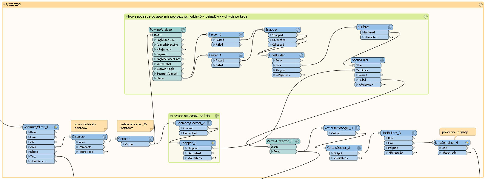
- CAD-to-GIS migration of projected railway axis schemes, with data processing elements applied where necessary. This task involved topology control and improvement (when required), as well as the completion of attribute data in the GIS system based on annotations present in the CAD files.
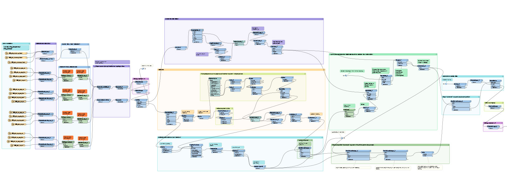
- GML geodetic data migration to GIS, carried out according to a defined final data schema. The geodetic datasets originated from two different GML structures and therefore required respective adjustments.
- Development of an automated FME Server-based procedure for data acquisition from the national cadastral register via WFS (Web Feature Service), covering as many as 54 poviats (counties). The main challenges included the substantial volume of data to be processed and the variety of data structures depending on the poviat, necessitating data unification.
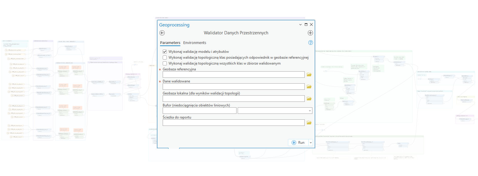
- Creation of the Spatial Data Validator – a specialized tool tailored to the Clients needs for the automated validation of data received from various sources and across different thematic areas. The validation algorithm, written in Python, enabled the Client to designate any file geodatabase as the reference (final) database. (tu brakuje tekstu) The Spatial Data Validator could read this metadata and validate incoming datasets accordingly. The validation criteria were flexible and easily adaptable to a range of thematic domains necessary for investment planning, such as geology, hydrology, and others.
The Client was provided with access to topological and attribute analysis through an intuitive graphical interface, offering the option to generate reports either as .xlsx files (listing errors and missing data) or as geometric layers with marked topological errors.
